


Rainwater Management
Problem Statement
During field visits and consultations with relevant stakeholders, three critical challenges were consistently highlighted:
Water Security for Wildlife in the Hilly Terrain A recurring concern is the lack of reliable water sources for wildlife inhabiting the forested Aravalli hills. This water scarcity often forces animals to descend into human settlements in search of water, increasing the frequency and risk of human-wildlife conflict.
Soil Erosion and Land Degradation
The hilly terrain of the Aravalli is highly susceptible to soil erosion, particularly during the monsoon season. Uncontrolled surface runoff, lack of vegetative cover, and historical mining activities have led to the loss of topsoil and contributed to land degradation. This not only reduces the soil’s ability to retain water but also affects the natural regeneration of native flora.
Declining Groundwater Levels in Adjacent Residential and Agricultural Areas
In the plain regions surrounding the hills, especially within residential and farming zones, there has been a marked depletion of groundwater resources. This poses a serious threat to both drinking water availability and agricultural productivity.
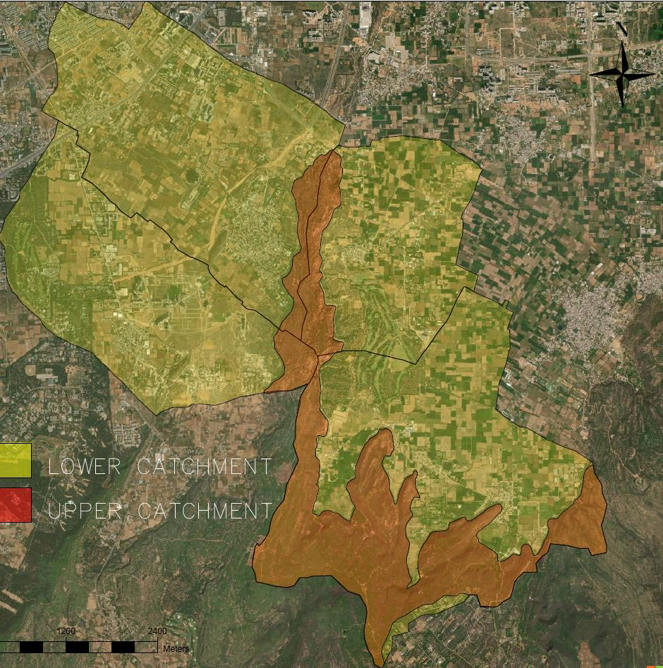
Map showing lower and upper catchment in the project area
Approach
In response to these pressing concerns, an integrated eco-restoration and rainwater management strategy has been devised for different land uses within the project area. This strategy is grounded in a comprehensive understanding of the region’s topography, ecological sensitivity, and hydrological dynamics. Accordingly, the site has been categorized into two dominant land use zones, each requiring a distinct approach:
Upper Catchment – Forest Area (Central and Southern Aravalli Hills)
This zone encompasses the undulating, rocky terrain of the Aravalli hills. The focus here is on ecological conservation, improving natural water retention, and ensuring water availability for a longer duration for wildlife through interventions such as gully plugs, contour trenches, check dams, and the creation of wildlife waterholes.
Lower Catchment – Residential cum Agricultural Area (Plain Region)
This area represents the downstream plain region comprising human habitation and farmlands. The focus here is on groundwater recharge, revival of traditional water bodies, rainwater harvesting, and improved surface water drainage to enhance water security for local communities and sustain agricultural activities. This dual-pronged approach ensures that both ecological and human water needs are addressed in a sustainable, location-specific manner, ultimately reducing environmental stress and fostering coexistence between people and nature.
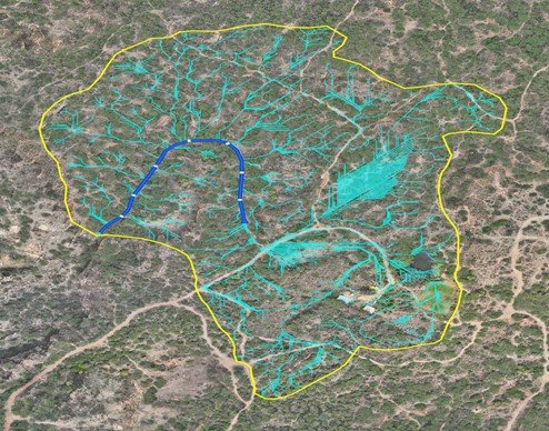
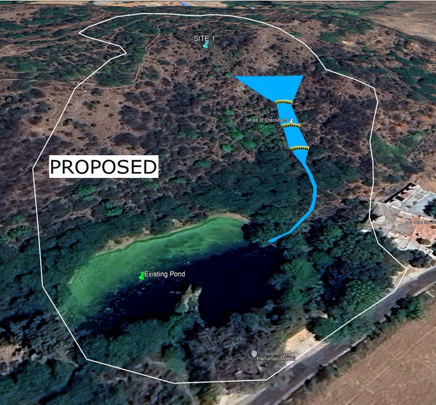
Rainwater Management Interventions in Upper Catchment
-
- Series of Check Dams – To slow runoff, reduce erosion, and promote groundwater recharge.
- Stream Rejuvenation through Gully Plugging – To restore natural drainage paths and retain water in shallow gullies.
- Contour Trenches and Earthen Ponds with Weirs – To capture and store rainwater, enhance infiltration, and support local wildlife.

Rainwater Management Interventions in Lower Catchment
Upper Catchment – Forest Area (Central and Southern Aravalli Hills)
This zone encompasses the undulating, rocky terrain of the Aravalli hills. The focus here is on ecological conservation, improving natural water retention, and ensuring water availability for a longer duration for wildlife through interventions such as gully plugs, contour trenches, check dams, and the creation of wildlife waterholes.
Lower Catchment – Residential cum Agricultural Area (Plain Region)
This area represents the downstream plain region comprising human habitation and farmlands. The focus here is on groundwater recharge, revival of traditional water bodies, rainwater harvesting, and improved surface water drainage to enhance water security for local communities and sustain agricultural activities. This dual-pronged approach ensures that both ecological and human water needs are addressed in a sustainable, location-specific manner, ultimately reducing environmental stress and fostering coexistence between people and nature.

Blue Roof: A blue roof is a flat roof design engineered to temporarily detain rainwater during rain events. It functions as an effective source control measure in urban and semi-urban rainwater management systems. In the context of the Aravalli lower catchment, where groundwater is extensively used for agriculture and domestic purposes, blue roofs offer a valuable solution for capturing rooftop runoff and directing it for reuse or recharge before it mixes with greywater.
Recharge Trenches: A recharge trench is a linear, shallow excavation filled with porous media (gravel, sand, and stones) that facilitates the infiltration of surface runoff into the ground. It is a widely used groundwater recharge structure in semi-urban and rural areas, particularly effective in locations with permeable subsoil.
Recharge Pit: A recharge pit is a deep vertical structure designed to collect and infiltrate surface runoff or treated water directly into the ground, helping to replenish the groundwater table. It is especially useful in semi-urban settings like the Aravalli lower catchment, where land availability is limited, and groundwater extraction is high.
Permeable Pavement: Permeable pavement is a surface treatment that allows rainwater to infiltrate through its surface into the ground below, rather than running off into rain drains. It serves as a dual-purpose infrastructure providing a hard surface for traffic while also supporting groundwater recharge and rainwater control. In the Aravalli lower catchment, where increasing impervious areas and groundwater depletion are key concerns, permeable pavements offer a sustainable solution that can be integrated into roads, parking areas, walkways, and community spaces.
Bio Swale: A bioswale is a shallow, vegetated channel designed to capture, convey, filter, and infiltrate rainwater runoff. Unlike traditional open drains, bioswales use engineered soil and plant-based filtration to remove pollutants such as sediments, nitrogen, phosphorus, and heavy metals from surface water. In rural regions like the Aravalli lower catchment—where rainwater mixes with runoff from roads, pavements, and agricultural fields—bioswales play a vital role in improving water quality and aiding groundwater recharge.
Percolation Pond: A percolation pond is a shallow, excavated basin designed to collect surface runoff and allow it to infiltrate into the ground gradually. These ponds serve as a cost-effective method for groundwater recharge, especially in semi-urban and rural landscapes like the Aravalli lower catchment, where large open spaces are available, and water demand is primarily met through aquifers. Percolation ponds can collect rainwater from multiple sources such as bioswales, recharge trenches, or overland flow, making them an essential part of integrated rainwater management systems.